You’re watching a flight on Flightradar24 and something looks off. One aircraft traces a smooth, confident path across the map. Another one nearby keeps jumping — position skips forward, drifts sideways, snaps back. Both are real aircraft, both are being tracked. The difference is how their positions get determined: one is ADS-B, the other is MLAT.
ADS-B: The GPS Broadcast
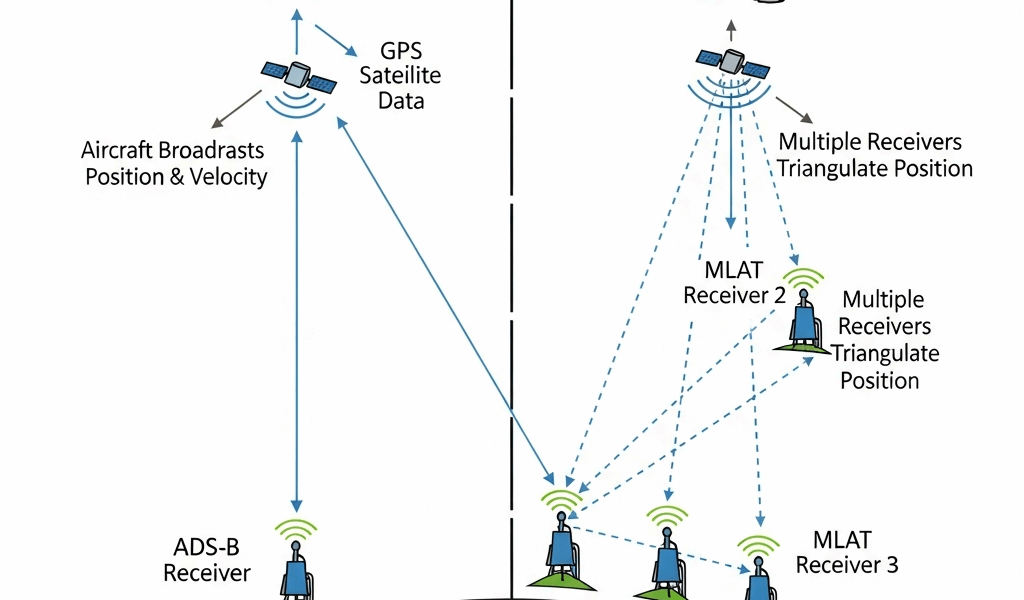
Aircraft with ADS-B Out carry a GPS receiver that continuously calculates position. The transponder broadcasts that GPS-derived position along with altitude, ground speed, heading, the ICAO 24-bit hex code, and flight ID on 1090 MHz — roughly once per second. No ground interrogation needed. The aircraft just announces itself.
A single ground receiver picks up this broadcast and immediately knows where the aircraft is. Position accuracy is GPS-grade, typically within 10 meters. No triangulation math, no timing synchronization, no multi-station requirement. One receiver, one aircraft, one clean position fix.
This is why ADS-B tracks look smooth on your flight tracker. Each plotted point comes directly from the aircraft’s own GPS. The ground station is doing nothing more than listening and forwarding the data.
MLAT: Triangulating Position Without GPS Broadcast
Older aircraft carry Mode S or Mode C transponders that respond to radar interrogation with altitude and an ID code — but zero position data. The transponder has no idea where the aircraft is. It just answers when pinged.
MLAT (Multilateration) works around this by measuring the Time Difference of Arrival (TDOA) of the transponder’s reply across multiple ground receivers. When three or more receivers record the exact moment the same transponder pulse arrives, the system triangulates position through geometry — conceptually similar to GPS, but running in reverse. Instead of a receiver using satellite signals to find itself, ground stations use a transmitted signal to find the aircraft.
The hard requirement: at least three receivers with decent geometric spread, and clock synchronization between them that’s better than you’d think necessary. At 500 knots, an aircraft covers roughly 250 meters per millisecond. Even microsecond timing errors between receiver clocks translate to hundreds of meters of position drift. The math is unforgiving.
Why MLAT Positions Are Less Accurate and Sometimes Jump
MLAT accuracy lives and dies on receiver geometry. Three receivers spread evenly around an aircraft give you a strong triangulation solution. Three receivers clustered on one side give you a weak one — the math amplifies every timing error when the geometric baseline is poor.
In metro areas with dense feeder coverage, MLAT works well enough. Plenty of receivers in enough directions to produce decent geometry for most aircraft passing overhead. Position might drift a few hundred meters compared to true ADS-B, but the track stays followable and logical.
In sparse-coverage areas, MLAT either fails outright (not enough stations for triangulation) or produces results that are obviously wrong. That’s why you see MLAT-tracked aircraft skipping around on the map. Each position calculation pulls timing data from different receiver combinations, and small timing errors create big position jumps. The aircraft didn’t actually teleport 800 meters sideways — the math just solved differently this second than it did the last.
ADS-B positions never do this. The coordinates come directly from the aircraft’s own GPS receiver. No triangulation dependency, no geometry sensitivity, no timing-induced jitter.
What the Labels Mean on Your Flight Tracker
Most tracking apps show the data source if you tap into the aircraft details:
ADS-B: GPS position from the aircraft. High accuracy, smooth track, reliable. This covers the vast majority of commercial aviation as of 2026.
MLAT: Calculated position from ground receiver triangulation. Moderate accuracy, may show gaps or jumps. Common for older GA aircraft, some helicopters, and military transponders that carry Mode S but not ADS-B Out.
No data / not tracked: Aircraft is outside receiver coverage, or its transponder type can’t be tracked by available ground stations. Standard over open ocean, where no ground-based receivers exist. Space-based ADS-B (Aireon satellites) is closing this gap, but not every consumer platform has full integration yet.
Estimated / extrapolated: Some trackers fill coverage gaps by projecting the last known position forward using speed and heading. Looks smooth on the map but the positions between actual data points are educated guesses, not measurements.
The Verdict: Why ADS-B Won and MLAT Is Fading
The FAA mandated ADS-B Out in most US controlled airspace starting January 1, 2020. European mandates followed close behind. The practical result: virtually every commercial aircraft operating in controlled airspace now broadcasts GPS position directly. MLAT is no longer the primary tracking method for airline traffic.
MLAT hasn’t vanished, but its territory is shrinking. The remaining use cases: older GA aircraft not yet equipped (the mandate covers controlled airspace, not all flying), military aircraft that carry Mode S but skip ADS-B for operational security reasons, and some helicopter operations in regions where equipage mandates haven’t fully kicked in.
The oceanic gap — historically the biggest hole in flight tracking — is being filled by Aireon’s space-based ADS-B constellation. Iridium satellites equipped with ADS-B receivers now track aircraft over open water. NAV CANADA and NATS (UK) already use this data operationally for air traffic control. Consumer platforms are integrating it at their own pace.
For someone watching flights on an app, it boils down to this: smooth track means ADS-B. Jumpy track or gaps means MLAT or edge-of-coverage. Neither label means the data is wrong — they represent different measurement approaches with genuinely different levels of precision.


Stay in the loop
Get the latest aerodata updates delivered to your inbox.